Sunday, March 30, 2008

Into the clouds

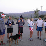
We ran Los Pinos trail again today – this time with Kirk. No one else showed up. And this is very understandable: the weather was pretty nasty in the morning – it was cold and drizzling. I barely managed to suppress a temptation to go back to bad when I opened the door this morning.
We started from Lazy W Ranch, ran all the way to the Main Divide and then back.
~ Overall elevation gain: about 5,000ft
~ Total mileage: 17.5 miles
~ Our time today: 5:19:05 (this does not include our pit stops)
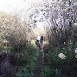
It was raining, but not as windy as the last time. I got wet through pretty quickly, as the trail is overgrown and you cannot run through these bushes without getting completely soaked with all the water from them.
After mile 4 it got pretty dark as we ran into a cloud. It felt like a sauna, except it was a way colder.
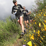
Even despite the weather condition we could not help noticing on our way up – through the tears – that the trail is freaking beautiful as everything was blooming on it.
On our way back we got passed by three mountain bikers. Should I add they were actually biking three, on those steep ridge trails? I am getting goose bumps on my back from just thinking about trying to ride a bike on the Los Pinos trail!
More photos from our run:

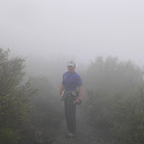
Los Pinos: into the clouds

Saturday, March 29, 2008

Trail Headz in Black Star Canyon

The Trail Headz had a group run in Black Star Canyon today, and it was a complete blast! I never ran in Black Star Canyon in a good weather conditions before. And the company was a way more attractive than the last time (no offence, Jeff:)


Unfortunately I had to cut it short and did not run all the way to the Main Divide with the rest of the gang and ended up with just 8 miles this morning. Did I mention there were around 20 runners from the club?

Here are a few more photos from the run:

SoCal Trail Headz in Black Star Canyon, 29-Mar-08

Wednesday, March 26, 2008

Los Pinos: directions to Lazy W trailhead


Access:
The upper trailhead is on North Main Divide road 5.8 miles from Ortega Highway (Hwy 74). The lower trailhead is in Hot Springs Canyon, 1.5 miles beyond the San Juan Fire Station off the Ortega Highway on the Lazy W Ranch. Trail ends on private property.

The Forest Service guidelines suggest you should call the Lazy W Ranch in advance of visit for permission to cross their property, but Lambert and Greg say that as soon as you park on Lazy W parking lot (which is not private) you can just walk through without any prior arrangements and no one will get offended.

Coordinates:
+33° 36' 6.39", -117° 30' 37.55" (33.601775, -117.510431)
If you post it in Google Maps, it will show you an approximate location of the Lazy W trailhead parking. You need an Adventure Pass to be able to park there.

Maps:

View Larger Map


Note:
The parking is a bit tricky to find. After you turn from Ortega Hwy onto Hot Springs Canyon Rd, you will need to drive up about a mile to the parking lot. The parking lot will be on your right under a bunch of trees. There will be a small rest room there as well. If you do not see it probably you are not there yet. On the other hand if you see any gates (especially closed ones) in front of you, the chances are you already passed the parking lot.

Tuesday, March 25, 2008

A pocket first-aid kit for ultras

The scratch I got at the Unknown race is not healing as fast as I expected it to, although it has been 10 days since I got it. I guess it did not help that I could disinfect the wound only over 7 hours later when I got home.

So two doctor visits and two cans of antibiotics later I came up with a short list of things I will always have with me at every ultra or long training run in the mountains:

- Neosporin (or Brave Soldier or any other antiseptic healing ointment)
- Alcohol wipes (individually packed)
- Gauze pads (individually packed)
- Medical adhesive tape (I prefer paper-based ones)

- Tetanus shot (you should be getting one every 10 years):
http://infectiousdiseases.about.com/od/faqs/p/tetanus.htm

Sunday, March 23, 2008

The Stairs

The Stairs Trail goes down from the West Ridge Trail down to the bottom of Laguna Canyon: I enjoyed climbing it up a way more than running down: at least it felt less suicidal.

It was strange to see so many bike tracks on those rocks. I wonder how it should feel riding a bike down this trail!

Thursday, March 20, 2008

VO2Max at Back Bay, Vol.1


I joined Jeff for his weekly VO2 Max workout today. Two observations:

1) I hate speed-work!
2) I should definitely do it more often!

We started at YMCA and ran all the way around Back Bay and back, and ended up with around 9.5 miles of overall mileage.

We did eight 1/2-mile VO2Max repeats with 1/4-mile jog intervals in between. I averaged at 6:40 min/mile, ranging from 6:20 to 7. Just in case: no, 6:40 was not my jog pace, but my VO2Max pace :) I am just that slow!

Jeff was cracking jokes all the way, which did not help either. It was like we see next 1/2 mile marker and urgently strive to stop laughing to be able to start the next speed interval.

As much as I am in love with trails and mountains, sometimes I miss my old road running days, and Back Bay in particular!

Wednesday, March 19, 2008

Purple poodle-dog bush: beautiful & dangerous


Just found an interesting atricle in OC Register


Purple-flowered poodle-dog bush, growing in burn areas, is hazard to humans.

A pretty purple-flowered bush blooming on the hills of the burned areas in Santiago and Modjeska canyons is a danger to people, according to the Department of Forestry.

The flower, commonly known as poodle-dog bush, is an irritant akin to poison oak, said forester Eric Oldar.

"This time of the year, the floral stalk is brilliant and it's very attractive, especially along hiking trails or roads where people make a stop," Oldar said. "They'll go out and actually pick it and take it home as a flower arrangement, not knowing that contact, for the vast majority of the public, will cause a poison oak reaction."

Symptoms range from itching to a rash or blisters lasting as long as two weeks. George Ewan with the Orange County Fire Authority said the pain is reminiscent to coming in contact with stinging nettles.
"It's like that that except it doesn't wear off," Ewan said. "It goes for quite a while."

Oldar said the bush is typically dormant, but bloomed as a result of the Santiago Canyon fire in October.

"It becomes prevalent after a major disturbance like fire or something that takes the area back to the barren ground," Oldar said. "It will blossom, grow, and eventually be replaced by other dominant vegetation until another disturbance occurs."

Oldar said the prevalence period could last as long as a decade, which is one of the reasons his department is trying to get the word out about the bush. Another reason is because of the attractiveness of the flower.

"This time of year, it can be a greater attracting to the public," he said. "Later in the season, the flowers drop and the shrub will continue to exist, but it has no particular characteristic that would cause the public to come in contact with it."

Oldar said people should go to their doctor if they start to itch. An over-the-counter remedy is calamine lotion or anything that has a cortisone derivative.
Ewan said avoidance is the best remedy.

"If you're going to go out into the foothills or into the burn area, be careful," he said. "There's a cute little flower out there that's purple and if you touch it, it's going to get you."

Monday, March 17, 2008

Fartlek Team Game Rules

I got introduced by one of my colleagues to Fartlek Team Game recently.
The guy that told me about it is an incredible runner himself with a 2:16 marathon PR under his belt, and he used to coach young pro-level athletes.

Fartlek Team Game is a very efficient speed-work exercise and a lot of fun at the same time.

1. Each team consists of two runners that pass a baton to each other

2. If there are multiple teams, it is recommended to shuffle runners either selecting partners flipping a nickel, or grouping the fastest and slowest into the same team

3. The Game takes 45 minutes sharp with no breaks

4. The Goal is to make baton travel around the track as many times as possible

5. The runner with the baton is running around the track at VO2Max level, while the second one is strategizing whether to run and meet the 1st runner half way or jog in the same direction as their partner to get caught a bit later

It is recommended to do speed workouts at least once a week.
I plan to integrate them into my weekly training (either with someone else or solo) starting this week.

Sunday, March 16, 2008

The Unknown

We ran in Charlie’s Unknown-?K race and it was just perfect: extremely neatly organized, challenging and at the same time a lot of fun. And I had a chance to see quite a few familiar faces there too.
There were only 30 runners divided into two 15-runner groups. Chaz calls it a supported group run, not a race.
I will not bore anyone here with all the details and detailed course description – just a couple of highlights.

I took off too fast – I should have put something slower or run without music for the first 3-5 miles – and Metallica’s Creeping Death is not the best pacer for the first miles of a race. But I had once-in-a-lifetime opportunity to pass iMichelle and Keira and I used it – even though they caught me at mile 10. They did not actually race as they are running a 100 miler right the next weekend. But when they do race I never see them on the trail, only at the finish line if I do not come there too late when they are gone already.
Mile 6: the run was so beautiful that I got caught in the moment on a rocky ridge trail and fell. I do fall from time to time but this time it was a notch worse than usual. I could still run ok, but I had scratches on my both palms, left elbow, and some scary deep and long bloody scratches on my left leg. And later on – around mile 15 – I fell on it once again, although the second fall was not that bad. Many thanks to Marisa who cleaned up the blood and dirt from the wound at the 1st Aid Station!
Mile 19 – right after the 2nd Aid Station – there was a stream crossing with some pretty unreliable wet small rolling stones. As I knew about it in advance, I planned to cross it in big white trash bags over my shoes. It almost work, but I still got wet a little bit as small stones punched wholes in the trash bags and let some water inside.
Finish – mile 33. I came there in 7 hours and 5 minutes or something like that. Just like at Mt. Disappointment and Ridgecrest I had some issues trying to find the finish line :) The food at the finish was prepared by a real gourmet chef, and was of a restaurant quality. I wish I was not so upbeat and could feel the taste more – I was just devouring it.
Overall the experience was completely wonderful. Looking forward to doing this thing next year as well!

Note: the Unknown course is 33-mile long (which is 53km) and has 6624 feet of total elevation gain.

More photos from the race:

The Unknown ?K

Greg published his recap from the race too. Greg also published his second recap with more photos.
Also check Lambert's web site with the detailed map of the course, its elevation profile and even more photos.

Thursday, March 13, 2008

A view from the top of the world

A bit belated recap of our long run on Sunday:

6AM felt a way too early and daylight time change did not help either. No wonder Linda refused to run this early! The parking lot at Awme was dead empty. It was dark and pretty foggy. I ran on Also Creek Bikeway with my headlight. I could barely see the trail ahead – all I saw was the bright fog in front of me. Next time I will wear headlight on my belt! So I ran 6 miles by myself to get some additional mileage and then returned to the cars to meet the rest of the group.

7AM: Jeff, Marisa and Linda are already there. Noticed I am a bit sweaty for the run start. After I explained my additional mileage thing, got reprimanded by Jeff and Marisa I had not told them in advance. It looks like I am not the only crazy one.

This time we checked out both Cave Rock and Dripping Cave trails. Marisa was leading the way and – as she always is – was jumping around inspecting every cave on our way. My incident with cacti I felt into in Laguna Canyon trying to climb a rock following Marisa did not teach me a thing.

Marisa climbed another rock, while I slipped and hurt my knee. It was somewhat embarrassing to get a hand from Jeff on a little hill Marissa just climbed on her own.

We were running in a fog, but as we started ascending Mathis trail, we got above it and enjoyed the most breathtaking scenery. All the creeks and canyons below we covered by a thick blanket of white clouds. The clouds were flowing over the ridges from one canyon into another. And everything above the clouds was lit by bright morning sun.

It is not like we need some additional cheering after Mathis ascent, but the sun did cheer us up anyways :)

As we got closer to the "top of the world" point, we spotted Soka University in a distance. It was surrounded by clouds from all the sides, but it is sitting on a hill that was rising above the clouds. It reminded me Minas-Tirith fortress from the Tolkien’s books.

Marisa just ran down the Cholla trail and was snooping around. She is always investigating the area around the trails. Only my 2.5 year old daughter behaves like that! After kids turn 4 they tend to become less curious and restless, but Marisa is definitely an exception! I am not sure what she was doing in those bushes (oh, not what you think!) but she is definitely happy about being caught in action.

Another highlight of our run was the bright green meadows on Wood Canyon with all the grass covered with morning dew and shining bright in the morning sun. It was also one of those "moments that take your breath away"!

As we got back to the parking lot, my GPS was showing 11.85 miles (in addition to those six I ran earlier that morning on my own). Jeff found it funny when I started circling around parking lot to get additional 0.15 of a mile we were missing to get 12 :)

SIDEWAYS
As we were running and chatting with Jeff – I quoted something from Sideways: “Strawberry, yeah!” It turned out Jeff never watch Sideways and never even heard of it. I was shocked. I turned to Marisa and Linda and shouted: “Guys! Can you imagine that? Jeff never watched Sideway!” I stumbled and almost felt when I hear back from them: “Side...what? Is it a movie?” It turned out Marisa did watch it once but did not recall the name at once and commented it was a “sick movie”. Linda saw just a part of it on an airplane. Sideways is a beautiful movie about California, vineyards and wine. Do you know that after Sideways became popular, sales of Merlot when down in California at the expense of an increase in Pinot Noir market share: “I am not drinking f$%g Merlot! If anyone orders Merlot I am out of here!” Anyways if you did not watch it, I would totally recommend it – just do not watch it when your kids are around – 99% of it is decent – there are just 2 or 3 moments that are R-rated although pretty funny anyways.
More photos from our run:

Aliso & Wood Canyons, March 9, 2008


Just for reference: a very decent map of Aliso and Wood Canyons:

Sunday, March 02, 2008

Los Pinos Rock 'n' Roll

We had a great time at Los Pinos this morning. I met Linda, Andy, Tim, Gabby and Steph Kinley in Las Flores and then we carpooled to the Lazy W Ranch. Actually I took my car as I was not sure how it was going to turn for me. I kinda injured (stretched) the Achilles’ tendon on my left leg last Thursday. I was running at my home hills in Ladera Ranch late at night – the ones that go under the power lines – and I failed to recognize a gap in the trail. And when I was running on Friday my leg was really soar and I was not sure at all I would be able to run on Sunday let alone running one of the toughest trails around – Los Pinos! On the other hand I was hoping I would be able to run all the way to Main Divide and consequently will need to leave after everyone else. That’s what actually happened and my tendon did not bug me at all. Another miracle of RECOVER-ease?
One of the first things that became pretty evident right at the parking lot was that I looked overdressed and over-equipped. I had long pants, long-sleeve shirt, camel bag with 40+oz of water, two 20oz hand bottles with Gatorade, GPS, MP3 player and a white Patagonia cap with a huge visor and a curtain behind it covering my neck. I though I looked like Badwater runner until someone told me I looked like a Badwater finisher. What? That bad already? We have just started the run! And it also looked like I had more water on me than the rest of our group all together :)

The first part of the run from the parking lot to the actual trail head was on a paved road that had three wide and at least one foot deep stream crossings. I felt a bit lost especially when we ran up to the first stream but Steph quickly found a bridge just 50 yards up the stream. Two other stream crossings were easier - the bridges were a way closer to the road.

When we hit the Los Pinos trail we saw a dozen of various signs with religious content and a big cross right at the trailhead. I had a feeling all those signs were telling us: “Guys, are you sure you know what you are doing? Think one last time before it is too late!”
The trailhead started with a pretty steep incline – so steep that at times it needed stairs. In almost no time we had to climb from 900ft level of the trailhead to about 2000ft which seemed even a way higher than that when we were looking at the Lazy W Ranch white roofs at the bottom of the canyon.

We did not see much of Steph after that. She took off and quickly disappeared in the trails ahead and above us. I could still see her as a small black dot quickly ascending another mountain from time to time but there was no way we could possibly catch her. I even worked out an official excuse based primarily on my potential tendon issues and a need to run conservatively to be able to continue ascent after everyone else turns back around mile 6.5. The excuse was lame but helped me, as well as the visor of my cap that completely hid the steep ascending trail ahead and the front runners.
Talking about front runners, we – guys – have to admit a complete defeat today. We were left behind. Pretty soon Gabby and Linda lost us as well. I saw them again only at the turn-around point at mile 6.5. If they did not stop there I doubt I would be able to catch up. So I was always wondering why Male and Female results are treated separately at the races, while there are a lot of extremely fast female runners like Nikki Kimball or Michelle Barton that tend to leave a lot of men behind if not all of them. I guess the men do not want to be intimidated like that and want to make sure they always get all the first places if not overall than at least in Male category :)
In a word, Steph, Gabby and Linda kicked our butt big time today. Gabby told me this was the second trail run for her – the first one was a 9-miler not that long ago. And before that she was mainly running marathons. I hope Los Pinos did not spoil the trail running impression for Gabby. If I were a road runner who went to try what trail running is at Los Pinos, it would become the last trail run in my life. I would never leave roads and track after that. But Gabby seemed to do great and looked strong at the turn around point.

One of the most memorable moments: around mile 3 we turned back and saw how clouds rise up from the canyon right in front of us, and how the wind tears them apart and throws pieces right at us. I wish I had at least some of a talent needed to describe it! Suffice to say it was so freaking awesome and surreal I was standing there nailed unable to take my eyes off it for quite a while.
The trail is extremely brutal. It is all covered with rolling loose rocks and running downhill is not much easier that going uphill. The incline is pretty steep and unless you are a complete animal – I know personally some folks that actually are, in a good way – there is no way you can run it. Crawling is a better word for it. My average pace today was about 17 min/mile, which is an absolute PR as my slowest 17 miler ever. Sometimes I could see that my pace was falling to something as low as 37 min/mile on certain uphill sections – a number I never saw on my Garmin before! Another PR: the slowest pace ever!
Add to all of that a hurricane wind on the ridge. We were having face wind or side wind all the way up. Had it been just a notch more furious I would be blown away from the trail down the slope into the canyon.
The cool thing about the trail was that I expected an overgrown singletrack – and it was overgrown indeed but not like the one we ran through with OCTR gang at San Mateo in December – this trail was not one of those that peels the skin from your legs as you run through it.

The elevation at where we parked is 800ft. The elevation at the highest point my GPS detected was at 4,550ft. So the net elevation gain was 3,750ft. I bet considering all the ups and downs, the overall elevation gain for the out and back should have been about 5,000ft, which is pretty close to Mt. Disappointment 50K :)
The ugliest part of the course was all of those last 5 miles (or 1 hour and 20 min) after mile 12.5, when I realized that I completely ran out of water and Gatorade. It was getting hot – now I would not mind some of our morning wind but it got pretty calm. I got to my car pretty dehydrated and had the most refreshing Gatorade bottle of my life. In a single very long sip.

Distance: 17.4 miles
Time: 4:55:05
Average pace: 16:58 min/mile
Overall elevation gain: something like 5,000ft

I ran all the way from Lazy W Ranch to Main Divide and back. And next to the Main Divide trailhead I did find those pines the trail was named after.

Tim's recap:
Los Pinos is BRUTAL that is the hardest trail run I have ever done....and it didn't help on the way back running what I thought was the wrong way...then doubling back and running/crawling back up that section of the trail only to determine I went the right way the first time. On the way up the wind gusts of 300 MPH and the cloud formations were supernatural.....it was strange seeing the clouds come UP the mountain at us. We turned back about a mile from Los Pinos...I drank 40 oz's and ran out about 4 miles from the car...I think I'm a better person from having run/walked this....that's why if you come by my house early Thursday morning you can get a free pair of trail shoes before the trash truck picks them up! :o)

Steph's recap:
I must say I think the only reason I was ahead is that I didn't really stop to look around, I was just trying to get to the top. The one thing I will say about that run is I always enjoy the downhill it's my reward for all the climbing but that trail was no reward It was almost as hard going back down.Oh and that wind was crazy it seriously blew me into the bushes a few times but that made me laugh. So needless to say that when I got home I took a nap, but I loved that trail it was amazing.

More photos from our today's run:

Los Pinos Trail: March 2, 2008